Drone missions often cover large areas while operating under constraints such as limited flight time, battery capacity, sensor coverage, and changing field conditions. AI-assisted planning can help operators determine which areas deserve attention, how to organize patrol routes, and which detected objects require further review. For businesses and public-sector organizations investing in aerial intelligence, the value lies in connecting flight planning with useful, location-based information.
For effective drone reconnaissance, route planning and target prioritization should work together. Research on UAV mission planning highlights the importance of balancing information collection, mission duration, target selection, and route constraints. Solutions such as Hunter Wing from Icecypress Technology address another important part of this workflow: turning aerial imagery into mapped detections and geographic information while the mission is underway.
Why AI Matters in Reconnaissance Mission Planning
Traditional mission planning requires operators to consider the area of interest, planned waypoints, flight endurance, sensor capabilities, and the information needed from each location. When multiple sites or potential targets compete for attention, choosing a practical route becomes more complex.
AI-assisted methods can analyze available information to help rank candidate areas, estimate the value of collecting additional imagery, and support route selection. Research has explored approaches that separate target selection from path planning, allowing planners to consider which targets matter most alongside the route needed to visit them.
For commercial applications, the same general principle applies to infrastructure inspection, environmental observation, emergency response, and large-site monitoring. The planning process should reflect the operational objective rather than simply minimizing distance flown.
How AI Can Improve Patrol Route Planning
A useful patrol route balances geographic coverage, mission duration, and the need to gather relevant information. A shorter route may reduce travel time but leave important areas insufficiently observed. A longer route may provide additional coverage while consuming more battery capacity and operating time.
AI-assisted planning can help evaluate alternative waypoint sequences against defined priorities and flight constraints. Depending on the planning software and available data, operators may consider target locations, revisit intervals, sensor coverage, and restricted areas when selecting a route. These capabilities must be verified for each platform rather than assumed to be included in every AI-enabled drone system.
During drone reconnaissance, updated imagery and location information can also help operators review whether the remaining mission should focus on planned areas or locations requiring additional inspection. Any route changes should remain subject to operator oversight, aircraft capabilities, applicable flight restrictions, and the mission’s operating procedures.
Target Prioritization: Turning Detection into Actionable Information
Route efficiency alone does not determine mission value. Operators also need to distinguish relevant observations from background details and understand where detected objects are located. Target prioritization provides a structured way to rank observations according to predefined criteria, such as location, object category, confidence information, and operational relevance.
A target tracking system may contribute to this workflow by helping teams associate observations with locations and review target information over time, depending on its capabilities. However, detection, geographic positioning, and continuous tracking are distinct functions. Buyers should verify whether a particular platform supports each required function before selecting it for deployment.
For effective prioritization, teams should establish clear review criteria and decide which detections require field verification. Confidence scores can inform this process, but they should not be treated as definitive proof that an object has been correctly identified. Human review remains important when observations are ambiguous or operational decisions carry significant consequences.
Hunter Wing: Connecting Aerial Mapping with Target Detection
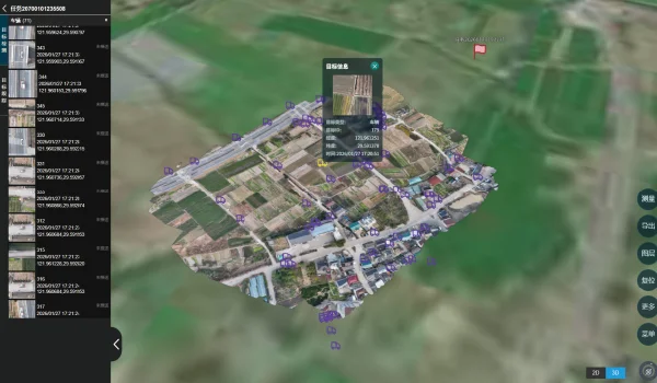
Icecypress Technology’s Hunter Wing is a lightweight, single-operator UAV mapping and target detection system. It combines real-time orthomosaic mapping, AI target detection, and geographic positioning during flight. These functions help operators view aerial observations in a spatial context instead of relying solely on imagery collected for later processing.
Hunter Wing has a stated target-detection response time of no more than 0.5 seconds under supported conditions. It can detect configured targets, including people, vehicles, and other objects of interest. Detection results can include target counts, categories, and confidence information, giving operators additional context for reviewing mission findings.
Detected targets can be displayed with geographic coordinates directly on the orthomosaic. The system supports sub-meter-level target positioning under specified operating conditions, helping teams identify locations for field verification. Imagery, mapping results, detections, and location data are streamed to the ground station during operation. Mission results can also be uploaded to a cloud platform or exported for reporting, archiving, and integration with downstream systems.
These capabilities make Hunter Wing relevant to organizations seeking a more connected drone reconnaissance workflow. It can provide information that supports operator-led target review and subsequent planning. However, the supplied specifications do not establish that Hunter Wing independently optimizes patrol routes or continuously tracks moving targets, so buyers should assess those requirements separately.
Integrating AI into an Operational Workflow
Successful deployment requires more than selecting a capable aircraft or software platform. Organizations should first define mission objectives, target categories, geographic boundaries, reporting requirements, and the conditions under which additional inspection is necessary.
They should then evaluate how the planning software, aircraft, mapping tools, and ground station exchange information. A target tracking system may need to share coordinates and observation records with existing geographic information systems or operational dashboards. Compatibility, data formats, connectivity, and access controls should therefore form part of the procurement assessment.
For teams evaluating smart aerial intelligence, Hunter Wing offers a documented combination of mapping, detection, positioning, and real-time data return. Its outputs can inform operational decisions, while route optimization and advanced tracking requirements should be assessed against the capabilities of the wider system.
Building a More Informed Reconnaissance Strategy
AI-assisted mission planning is most useful when route decisions, target priorities, and field observations are evaluated as connected parts of an operational process. Organizations should compare solutions against measurable requirements, validate performance under representative conditions, and retain appropriate human oversight.
Icecypress Technology‘s Hunter Wing provides a practical option for teams seeking real-time aerial mapping and geographically referenced target detections. By combining these capabilities with suitable planning tools and review procedures, organizations can develop a more informed drone reconnaissance workflow and evaluate whether a dedicated target tracking system is needed for their specific operational objectives.
